
Hiking trails and nature trails as of 06/Oct/2020 -- The CAMPGROUND ARE OPEN
Volunteers and paid construction crews have been restoring the hiking
and nature trails in the Crystal Lake camp grounds. All of the hiking
trails within the campground and surrounding the campground are in
excellent and safe condition.
TO REPORT TRAIL PROBLEMS and to get them scheduled for repair, please
email us to us know what trail problems exist and we will let you know when
they have been fixed -- if they can be. Photographs and possibly GPS
coordinates for trail problems sent to us are a big help.
Download a trail map here and then print a copy.
Copies of this map are available for free at the Visitor
Center though the news stand out front may be empty. Inside when the
Center is open there are more.
For a color map that also shows the trails,
CLICK HERE and notice that there is a trail called
"Wawona" which often does not appear on maps.
- Hawkins Ridge Trail -- This trail gets periodic maintenance done by
the San Gabriel Mountains
Trailbuilders, details of which you can find at
this link here
which describes the progress being made on the hiking trail. (Also see
Dan's Hiking Blog which shows restoration efforts.) There is hope that
the trail will get maintenance work done in March of 2016.
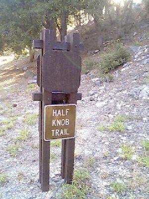
- Half Knob Trail -- This trail was completely restored and is
currently in excellent condition. This is a short hike trail
which begins and ends at points along the main paved roadway leading
to the Visitor Center. The trailhead is located at North 34 degrees,
19.444 by West 117 degrees, 50.210 at 5717 feet. (To see maintenance
efforts on this trail,
you may
click here.)
- Lake Trail -- Lake Trail is in great condition with the start of the
trailhead having a new rock bridge built by volunteers. The trail
cuts across the camp grounds and joins the main road that heads up to
the Visit Center to Lake Road. The start of the trail head from the
main road end is located at North 34 degrees, 19.410 by West 117
degrees, 50.261 at 5744 feet. (To see maintenance efforts of this trail,
you may
click here.) In March of 2014 there was some additional erosion on the
trail reported however it's not serious.
- Golden Cup Nature Trail -- This trail has been completly restored.
There was extensive flooding along this trail. This is a short hike
with four or five information boards placed along the trail. The trail
itself forms a loop such that the start and end of the hike is near a main
paved road. The trailhead is located at North 34 degrees, 19.630 by
West 117 degrees, 50.108 at 5865 feet. (To see maintenance offorts of
this trail,
you may
click here.) Currently the start of the trail has some erosion which
is scheduled to be repaired.

- Big Cieneca Trail -- This trail has been periodically repaired and
all of the known downed tress across the trail have been removed. Because
parts of the trail are in the 2002 Curve Fire burn area, more trees have fallen
across the trail so there can be new obstructions from time to time. This
trail is 1.2 miles long and has its start at the South Mount Saint Hawkins
dirt road which has been abandoned. There are a number of chronic washouts
along this trail however you should be able to continue to find the trail
fairly easily. (To see maintenance of this trail,
you may
click here.)
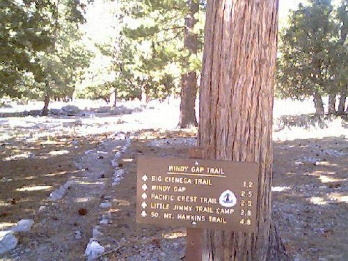
- Windy Gap -- This trail has seen considerable maintenance over the
years with dead trees obstructing the trail removed, boulders blocking the
trail levered over the side, and tread work being done as needed. This
trail is 2.5 miles long and has its start at a paved parking lot that
is North of the Visitor Center. The lower trailhead is located at North
34 degrees, 19.890 by West 117 degrees, 50.021 at 6099 feet. Trail
maintenance efforts continue to be made every year though a number of the
Sutter Walls that were installed by a contractor have been damaged due to
falling trees and rock slides. Also there is one spot where rock and dirt
has inundated the trail so you will have to scramble carefully across that
spot. (To see maintenance of this trail,
you may
click here.) There is a
Facebook Page For the Windy
Gap Trail HERE which you should go and Like if you use Facebook.
- Pacific Crest Trail -- A section of the
Pacific Crest Trail can be accesses from
the campground by hiking up Windy Gap Trail or taking Wawona Trail up to
Islip and from there to Pacific Crest Trail. From Windy Gap Saddle it is
1.4 miles to the start of Hawkins Ridge Trail, yet the condition of that 1.4
miles is not currently known.
- Little Jimmy Trail Camp -- The trail from Windy Gap Saddle all the way
to Little Jimmy is in excellent condition. This trail is 0.3 miles long.
(For information on Little Jimmy,
click here.)
There are some missing trail signs which are scheduled to be installed.
- Pinyon Ridge -- This trail was fully restored during National Trails
Day of 2006, and it continues to be maintained in excellent condition.
This is a moderately short trail of about 1 mile which forms a loop
that takes hikers up the side of the mountain ridge, along the ridge, and
then back down again, curving around to form the loop. The trail head location
is the same as the start of Soldier Creek: North 34 degrees, 19.354 by
West 117 degrees, 49.976 at 5656 feet. (To see maintenance of this trail,
you may
click here.) Also
there is a Facebook page
HERE which you should go Like if you use Facebook.
- Soldier Creek Trail -- Fire damage and flooding caused significant
damage to this trail and it was considered a complete loss for a number of
years however the Trailbuilders and fire fighters were able to restore the
trail to the point where it is once again safe to use. The trail head
location is the same as the start of Pinyon Ridge trail: North 34
degrees, 19.354 by West 117 degrees, 49.976 at 5656 feet. (To see
maintenance on this trail,
you may
clock here.) As the burned and diseased trees continue to age, tree
limbs continue to fall on the trail however they are usually removed
quickly after they get reported.
- Lost Ridge Trail -- This is another excellent hiking trail which has
been fully restored by the San Gabriel Mountains Trailbuilders.
This trail is just about one mile long with one end of the trailhead
up near Deer Flats and the other end on Lake Road. To increase safety, the
Trailbuilder crew installed steps in a number of places and the volunteers
may decide to install more steps in moderately steep places in the future.
The lake road trail head is located at North 34 degrees, 19.452 by West
117 degrees, 50.463 at 5728 feet. The other end of the trail is in
the Deer Flats Campgrounds and it's located at North 34 degrees, 19.977
by West 117 degrees, 50.365 at 6344 feet. In the Summer of 2011 the
extensive plant growth along the way had been cut back and all of the downed
trees obstructing the trail have been cleared.
(To see maintenance of this trail,
you may
click here.) Also
there is a Facebook page
for the trail HERE which you should Like if you use Facebook.
- Tototngna Nature Trail -- A great deal of work has been performed to
re-define and open-up this trail to the point where the entire loop can be
hiked. This is short nature trail of 1 mile which forms a loop and
can be accessed from a paved road. The trail head is located at North 34
degrees, 19.538 by West 117 degrees, 49.767 at 5929 feet. Becuase the
trail forms a loop, the Y where the trail splits has a sign showing the way.
(To see maintenance done on this trail,
you may
click here.) Also
there is a Facebook page for
the trail HERE which you should Like if you use Facebook.
- Cedar Canyon Trail -- This trail has its start on the main road
leading up to the Visitor Center. It's a moderately long trail
that leads to a good volume of water. The trail actually meets up with
Soldier Creek Trail which has been restored fully. The trailhead for this
end of the trail is located at North 34 degrees, 19.366 by West 117
degrees, 50.280 at 5820 feet. (To see maintenance done on this trail,
you may
click here.)
- Sunset Ridge Nature Trail -- This trail is located inside of the
Deer Flats Campgrounds. It's a short trail of about half a mile
which forms a loop that ends about 30 feet from where it begins. The
trail has been fully restored. The location of this trail is at North
34 degrees, 20.002 by West 117 degrees, 50.249 at 6423 feet. There is
also a
Facebook page for the
trail HERE which you should Like if you use Facebook. Note that Sunset
Ridge Trail does not show on most of the trail mails that one can find for
the campground.
Wawona Trail -- The trail that leads from the lake's lowest parking lot
all the way up to Islip Ridge is called Wawona, and it is in good shape,
having been worked on considerably in 2013. There is still some work that
needs to be done up at the top of the trail with brush needing to be cut
back however that may be done shortly. Some maps show this as Islip Trail
and some maps show it as Wawona. The correct name is Wawona.
During the year the
Trailbuilders continue to
maintain all of the hiking and nature trails within the Crystal Lake basin
unless there is too much snow on the ground to make maintenance possible.
In addition to the established trails, hikers can also pack water and
walk up to the old
Mount Saint Hawkins>fire watch
tower which burned down to the ground in the last series of fires. The dirt
road up to the destroyed fire tower is currently in "damaged"
condition at one point where a major washout has taken place. Because the
road has been officially abandoned, the condition of the road is expected
to deteriorate over the coming years until much of it simply disappears.
